
A hands-on workshop to defend and grow the core at local landscape scales
The Sagebrush Conservation Design (Doherty et al 2022) issues a call to action for strategic, landscape-scale management to conserve the sagebrush biome across the western US. It promotes a proactive framework to strategically defend and grow intact core sagebrush rangelands, which can be applied at scales ranging from the biome level to local landscapes. Partners from Oregon State University extension, the Institute for Natural Resources, and the Agricultural Research Service have developed a model for a hands-on, interactive workshop to facilitate landscape-scale, proactive planning to implement the ‘Defend and Grow the Core’ framework in complex local landscapes with multiple threats and values in Oregon. This responds to the need to help local stakeholders work through a process to apply these concepts at management-relevant scales, empowering managers and practitioners to conduct proactive, strategic landscape management within their area of influence.
Threat-Based Strategic Conservation builds upon a solid foundation of existing work, including the Sagebrush Conservation Design, Threat-Based Land Management (Johnson et al. 2019), lessons learned from locally-led collaboration in Oregon such as the Harney County Wildfire Collaborative, and five general principles for strategic landscape management planning (click button below for overview).
The workshop format consists of a curriculum centering core principles for strategic conservation, the Defend and Grow the Core framework, and threat-based land management, followed by a hands-on workshop discussing how to apply these concepts in a real landscape. The core principles emphasize elements like centering the ‘why’ of management to frame what will be done on the ground and help prioritize actions, and identifying the relevant scale for strategic conservation planning based on both the ecological and social stakeholder dynamics. Additionally, we emphasize that maps and technology can be helpful tools but that strategic conservation is not a map but is a mindset.
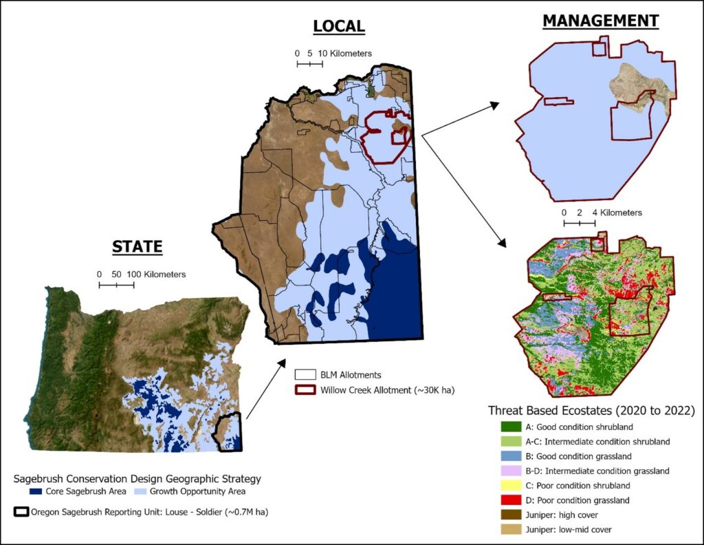
After the introductory content, participants are introduced to the Sagebrush Conservation Design maps and threat-based ecostate maps for a focal landscape (generally 200,000-500,000 acres in size) that is used for the workshop exercise. The Sagebrush Conservation Design maps help place a landscape in the broader state-wide or biome-wide context, and threat-based ecostates identify more localized core sagebrush areas and growth opportunities, along with threats from invasive annual grasses, fire, and conifer encroachment. ‘Defend and Grow the Core’ is used as a common language to communicate a spatial strategy for proactive management, and threat-based ecostates including states A, B, C, D etc are introduced to better understand the specific localized threats.
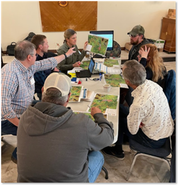
Finally, using the SageCon Landscape Planning Tool, participants are led through a series of prompting questions designed to spark conversation about strategic management within the focal landscape. At each step, an example is provided and small groups discuss the following questions:
- Where are the core sagebrush areas, growth opportunity areas, and other rangelands in your landscape?
- What are the primary threats in and around larger blocks of core sagebrush areas? Are there areas where it will be especially important to limit threats or contain infestations?
- How might you change your map of core or growth opportunity areas given other factors like resistance and resilience, fire risk, sage-grouse habitat, road access, etc? Are there places where stopping fire or containing threats like invasive species is critical to protecting core?
- What are your priority areas for management, and where would you start? How would you protect your investments?
Small groups are facilitated and encouraged to discuss their responses to the questions and offer differing visions of how you might approach the challenge of defending and growing core sagebrush rangelands, overlaying multiple values, prioritizing threats, and protecting investments. At the end, each small group shares with the broader group their thought process and lessons learned from the exercise.


This model can be expanded and honed to respond to partner interest and adapt to multiple locations, audiences and formats throughout the sagebrush biome. Future next steps may include refining and developing additional content for potential additional elements or modules and helping partners adopt these workshops outside of Oregon using additional tools and datasets. Additional modules and content may take multiple formats, such as an online course, presentation materials delivered through train-the-trainer workshops, facilitator guides or instruction manuals, multimedia content such as videos, and/or other formats. We are also exploring the use of these workshops in facilitating local strategic spatial planning for Local Implementation Teams in Oregon.
